


lilbill15
-
Posts
409 -
Joined
-
Last visited
-
Days Won
3
Content Type
Forums
Gallery
Events
Shop
News
Audio Archive
Timeline
Posts posted by lilbill15
-
-
Lovely! Thank you for this, I’ll take a careful look tomorrow if it doesn’t rain. I’m a bit dubious how much I’ll find as I suspect a lot of the history is under the new houses. I’ll track the Letch, make note of where the houses stop and what remains of the wagon way (?Lonnen). Now you’ve described the approach to the “scary bridge “, I think I know where you mean- from the SE corner of the concrete things field there is a very steep and muddy when wet, slippery slope down to water I’ve heard below. I’ve tried a couple of times and chickened out plus once tried to get down when Josephine was with me but we both agreed it probably wasn’t worth the risk. However I’ll be approaching from the opposite direction tomorrow so it might look different from a different angle? I’ll definitely keep my eyes open for old shafts etc and if it looks dodgy I’ll just go home instead.
Looks like your path to Westmorland|Northumberland Aves is still there snaking through the new houses-that’s another day out for Me’nMax xx -
Just an afterthought- you mentioned a “scary bridge “? Whereabouts is/was it, please? Regards Roseanne x
-
Hello there @Canny lass, I know exactly what you mean about the small script on the phone, struggling to see yesterday’s map gave me a headache. I’ve just read your reply but I don’t have a PC, I vowed after retirement never to go near one again 😂x. I had a fresh look this morning and I’m sure you’ve got the right position for my Willow Bridge approach. Have been able to expand enough to see that it’s just numbers beside what are probably field edges. There’s no sign or suggestion of any buildings in the area where I’ve seen the earth/brick piles but there’s nothing to say the old brickyard wasn’t spread wide over the area when it was demolished? Also currently no reason to think maybe it is being prepared for some construction? I’ll just wait to see. If this weather holds Me’nMax are going to follow the GLETCH from North Ridge to it’s junction with the Netherton Letch and back around to Blue House, seeing it with different eyes and looking for markers of previous communities, esp Francis Pit. Photos to follow 🤞🏼X
-
7 hours ago, HIGH PIT WILMA said:
Hi Folks! Alan,many thanks for that bed time reading! A think my best bet is to first scan the pages,like it says ,if only to preserve a clear image,as the ink IS starting ti fade. A haven't had books one and two oot the carrier bag in the drawer where they are kept,for a few years..time flies!!..and a took them oot yistidi mornin',ti let wor lass read them,and book one one was written wi a fineline pen,and aam sure it looks faded aalriddy.
Aa started reading book one ,just ti check it oot, a few pages like,and a got absorbed and interested in thi bugga...and a thowt...it's MY story,and AA wrote the bugga!![Hoo crazy is that?!!..aav forgotten wat a wrote aboot me childhood,even though aal of it is still fresh in me mind!]
Aam not that clivvor when it comes ti pdf's word documents etc,aav nivvor done owt at aal wi Word,and a wadn't knaa wheor ti start!
Mind, aav got a ton o' patience,so sitting printing oot 600 double sides,[ie 1200 sides!..],doesn't bother me at aal,it's just thi time factor involved,it's 24 hour care more intense noo wi me Wife,since she had another big Seizure on May 1st ,at 6-20 am,resulting in a fall from a standing,seized,position,forward onto her face,flat oot,which bust her face aal up and broke her nose.
So aam waatchin' her like a Haak,and the days just fly by wi being on thi go aal day.
So,aal hae ti try and dae a bit at a time before thi ink fades and it will aal hae been a waste o' time!
Cheers Alan,and lilbill,from this Bill!!
Morning x lilbill to BigBill @HIGH PIT WILMA, burning the midnight oil there? Been thinking about your book; wondering whether there are any grandchildren or suchlike? The young’uns are the ones who are familiar with technology and, judging by the speed when I see them texting all over the place I’m thinking maybe you could ask if there’s anyone who can do your transcripts for you? Or possibly a local school? It’d make a great project and pass on your knowledge and experience at the same time. Probably a daft idea but maybe worth giving it a thought? Best regards BigBill, from lilbill xx
-
5 minutes ago, Canny lass said:
I'll look forward to seeing them! It must be at least 40 years since I was anywhere near.
I was born 57, you? x
I’m going to have to rest my eyes a while, that last map looked spot on but I’m struggling to read the small print so I’ll take a breather, BEST regards, Roseanne x
-
Someday soon, when the weather is right, Me’nMax are going to follow that little line from close to Ewart Hill to the Sleekburn junction, taking a picnic and iPhone to record the events and send you some pics xx
-
 1
1
-
-
32 minutes ago, Canny lass said:
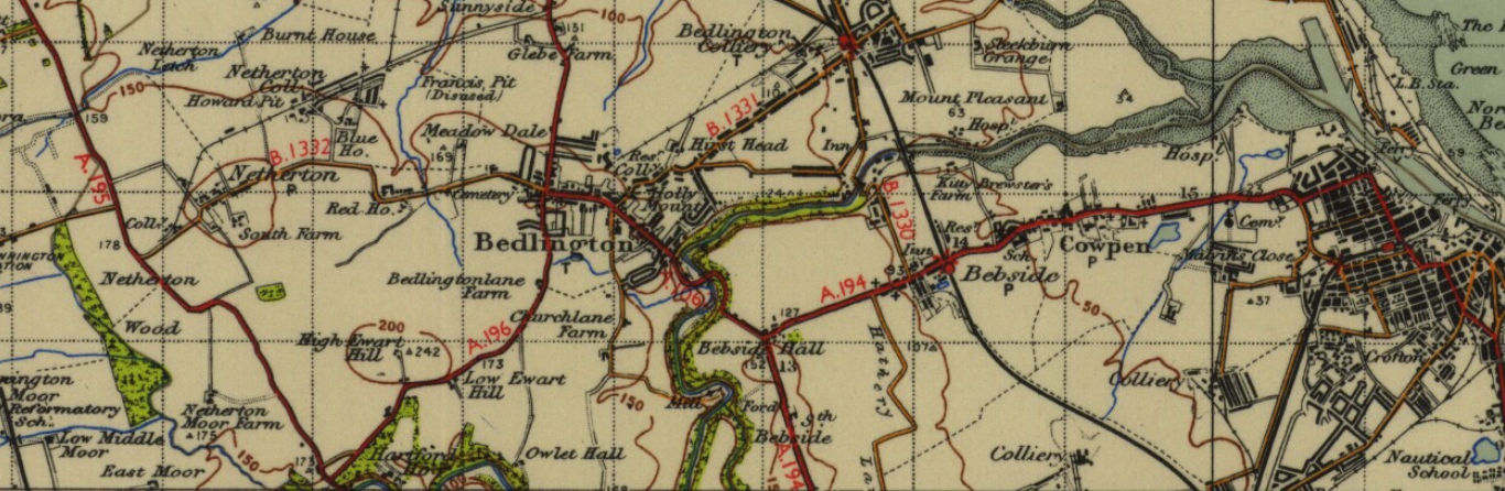
.... and here's a map from 1947 showing the origin of the Green Letch just north of Ewart Hill. It's the blue line starting just to the west of B in Bedlington.

Yes, lovely, fits perfectly x. I’m (irritatingly) wondering what it’s source is? Where does the water come from? That’s bye the way.
On your previous map between the E &D of the upper Bedlington inscribed on the map there’s something marked on the vertical line between Netherton Letch and the railway line. I can’t make out what it says....
-
Good evening @Canny lass, so, Netherton colliery esp. Francis Pit, is much nearer to West Bedlington than I realised. Also GLetch does veer Westish before heading to Choppington area. Looking at your latest map I can narrow down the area of “concrete things “, to somewhere the green and Netherton Letches meet to the east of the area in question. Do you have the legend for this map? I’m not sure what the various lines/dotted lines stand for-?footpaths/field boundaries etc. I’ll try to indicate on the map you sent me what I am looking at, thank you thank you xx
-
Wizard!! 😳xx
-
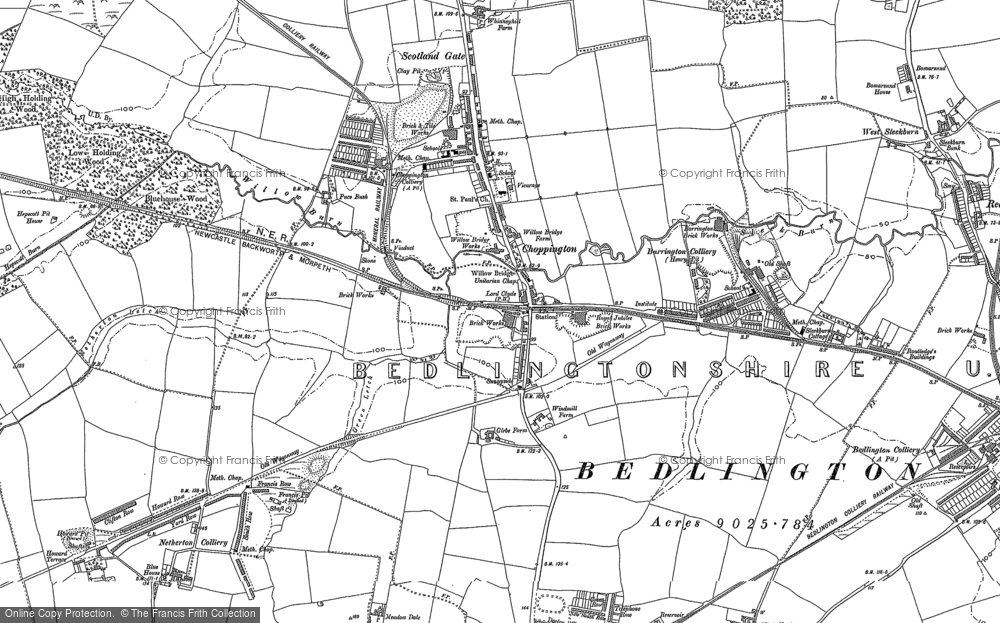
4 hours ago, Canny lass said:
Sounds like the Netherton Letch, shown in red. Naturally, I've painted the Green letch in a suitable shade of green:
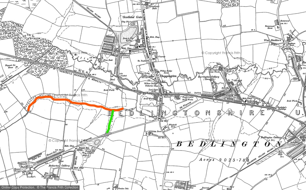
Hello @Canny lassYup! That’s definitely green 😃x Thank you very much for this x, although I’m not happy with this map, the Green Letch is indicated nearer Netherton than I think it really is. I’ve found one map suggesting it originated near Low “Eweherd”Hill (love to think about sheep), and runs North to join the Sleekburn eventually. I live on North Ridge Bedlington and I can look out of my window and see the course of the GLetch beside the bus stop across the road (B1331). I know you said that maps are really snapshots and I recognise they’re only as good as their authors. However, all that blether aside, I can now add Netherton Letch to the pot, and that does fit the picture. If I stand with my back to the “concrete things “ field, looking South, the GLetch is over to my left, at 9-10 o’clock ish. The Netherton Letch must be what runs in front of me from right to left, low down below in a deep gully. From this position I can look South and see the edge of the new houses built alongside the B1331. There’s a path I haven’t tried yet which drops down the steep slope down to the water, next step has to be follow this to see if this is where the Netherton and Green Letches meet? Best regards Roseanne xx
-
Also wondering what the two features adjacent to Francis Pit are (round/oval’ish ‘’’’’’’ markings around them)?
-
It’s not the Green Letch- there’s another stream travelling from West which looks like the Letch drains into?
-
15 minutes ago, Canny lass said:
Could it be the remains of Choppington Brickworks?
It's just a small dot behind the Lord Clyde pub (above centre) on this 1896 map of the greater area of Netherton, Choppington and Barrington. As you can see, there are Brickworks the length of Choppington Road. Probably half of Bedlington is built of bricks from here. I know that the newer rows: First-, Second-, Plessey- and Third Street were.
Here's a close up. I'm afraid I don't know from which year.
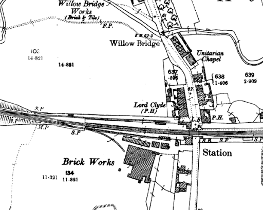
If the remains are very near the Choppington road it's most likely to be this. There wasn't much remaining of the Francis pit houses when I grew up in the 50's. Only their gardens remained as allotments behind the new First Street.
Morning @Canny lass, thanks very much for this, more ingredients for the Bedlington pot x. I don’t think it’s the brickworks itself as the area lies not far from the Green Letch which is on my right as I face the Choppington road and approx 10-15 minutes walk from the road (sorry, I’ve never been able to judge distance). I usually approach from Blue House direction, but I followed a new path (to me) Sunday morning from Willow Bridge, past “the Deck “, over the railway line and eventually met the Green Letch and the brick/soil/stone area was on my right with the field of “concrete things etc “ on my left, north side of the Letch. It actually looks like recent movement of the area, making me wonder if it’s being dug in preparation for something or maybe just reclamation because the bricks and stones look old and mixed with soil and ?bulldozed into big heaps, good stone separated out. Alan Dickson has said he thinks the concrete things could be vents for an old clay pit which subsequently became a landfill. I have downloaded one old map app so far and was browsing when I got your response, yours is a much better map than I’ve found so far and I’ll try to find some comparisons to nail down the location in question. I’m just learning how to use Google Earth while I’m out and about, apparently it’ll give me map coordinates for wherever I am so I can reference it when I get home. Thanks again, regards Rx
-
Also.... now you’re getting sick of this! - there’s a grotto marked between Humford mill and? Attlee park, does this feature on any subsequent maps? Also interesting, iron mine near Foundry Bridge, makes absolute sense but never occurred to me that the iron was local originally. I’ll shut up for a bit xx
-
58 minutes ago, Canny lass said:
Now, I've located the map I was looking for! Ewe herd Hill goes back much further than 1820. here it is on what, according to me, is a very beautiful map of the area from 1769:
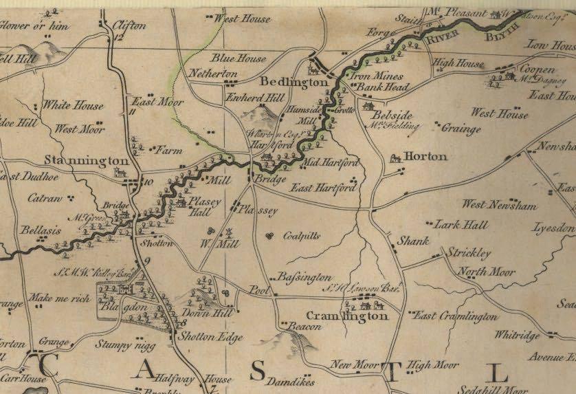
Very lovely indeed , @Canny lassdetails like the naive depiction of Ewart’s hill, making it stand out as a feature more significant then than it seems now. I’m wondering whether the mining activity has reduced it’s prominence in the same way the A pit heap has reduced over the years? I had a good look over that way this evening and there’s nothing so obvious on that horizon. Also, there is some evidence of industry in that area now, is there currently some excavation going on between RedHouse and Hartford road? x
-
9 minutes ago, Canny lass said:
These are my favourites:
https://www.oldmapsonline.org/
https://www.visionofbritain.org.uk/maps/
Enjoy!
Wow @Canny lass, now who’s inundated? HOURS of rummaging here, thank you very much xx
-
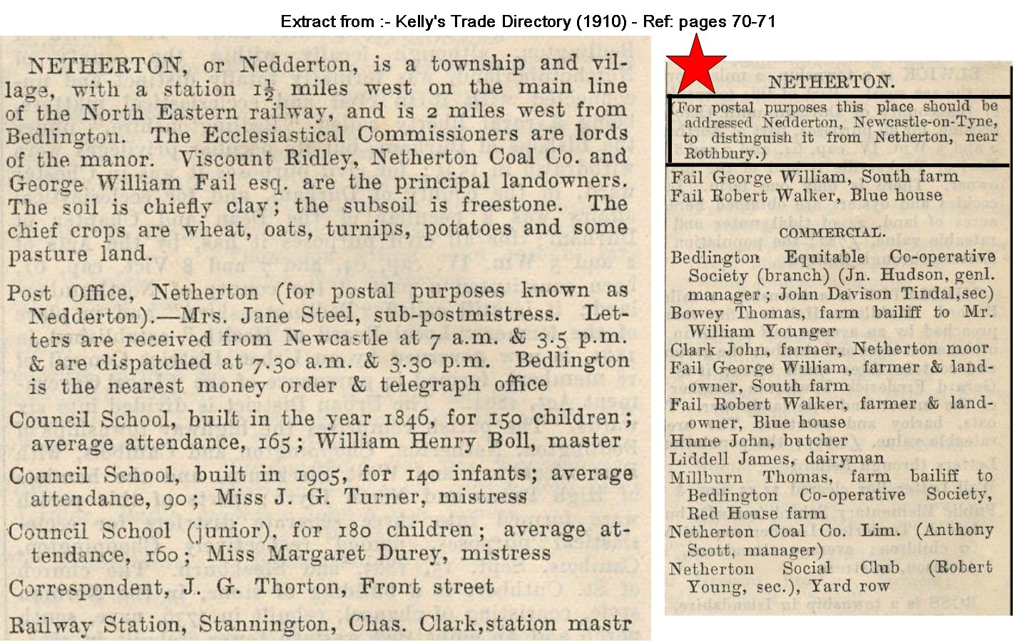
28 minutes ago, Alan Edgar (Eggy1948) said:
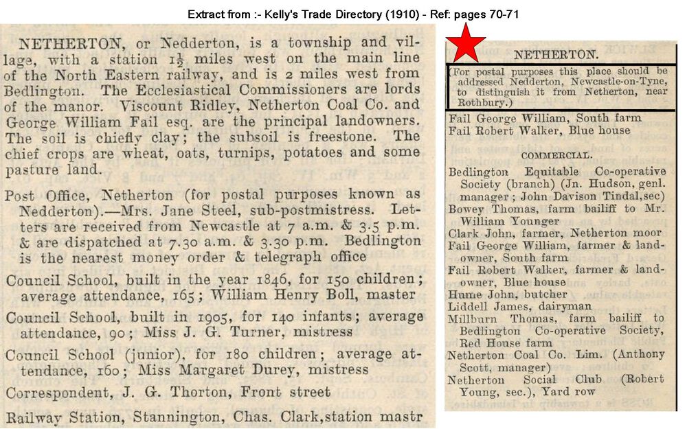
Well, seemed straightforward differentiating between the village and the colliery, so why wasn’t the colliery called Nedderton colliery to avoid confusion with Rothbury’s Netherton? Post Office has a lot to answer for (seems a little high-handed, like their computerised accounting system?) just having a dig😂x
-
17 minutes ago, Canny lass said:
The community named Netherton on the map is what we now call Nedderton Village. The name was changed due to postal confusion when Netherton Colliery came into being – that’s to say the community that grew around the Howard- and Francis Pits.
What we previously knew as Netherton Colliery isn’t shown on this map. Probably a bit too early. Maps are great things but they are like photos – they record only a moment in time. Unfortunately, the ‘moment’ captured in the survey may, very often, not bear any resemblance to the area at the time of publication. That’s particularly true of maps from the 19th century as, in order to keep pace with the needs of growing Industry, coal mines were springing up all over the place at a fair old rate of knots. Map-making, on the other hand was a long and tedious process.
Netherton Colliery community doesn’t appear in any detail until housing started to be provided. Though there were as many as 14 mines (not all coal producing) late 18th century in and around Netherton the area was predominantly arable land. Blue-, Burnt- and Redhouse Farms were already established way back at the beginning of the 18th century on land belonging to the Ogle family. The first ‘pit’ of any size was at Nedderton Village around 1789 but it wasn’t until 1837 that any major production started at Howard pit – around which the colliery rows were built. Production was good and in 1846 another shaft was sunk to give better access. This was the Francis pit. So, it was a bit after 1820 that any community worthy of notation on a map was established at Netherton Colliery.
Oh, thank you for this- loads of information here. I suspected that’s how Nedderton came to be, am amazed that there were as many pits as that. I have wondered about piles of brick-riddled earthworks and hewn stone in a field over towards the Choppington road, having seen Francis Ville? street sign, plus subsequent info about Francis pit, whether they are the remains of an extinct community between Netherton colliery and Willow Bridge area? I’ve got loads of questions but I’ll try not to inundate you. I would appreciate your advice on where best to find old maps of the area? Best regards, Roseanne x
-
1 hour ago, Canny lass said:
Apropos Ewart Hill, did you know that it was originally called Ewe herd Hill? I've always thought of Ewart as family name but Ewe herd Hill was clearly a way of describing a landscape feature ( a hill where there were shepherds living or working). Here it is on Fryer's map of 1820:
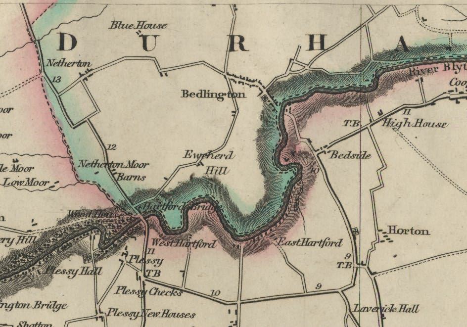
Now, that is interesting, I like to see how place names change over the years, just like language. I can see no sign of Nedderton on this map, has it replaced what was Netherton, well along the road from the Blue House? Maybe another name which has evolved over time? You know, I start off with a plan and get diverted all around the houses with each new snippet of information- fascinating stuff. Thank you very much x
-
1 hour ago, James said:
I have no dates of the years that the Ewart Hill pit was in operation but the map shows it was disused in 1897. It had only one shaft 361 ft. deep and worked the Low Main Seam. Following the Hartley Colliery disaster in 1862 when 204 men and boys died of carbon monoxide poisoning, all collieries had to have at least 2 shafts so that in the event that one shaft was out of action or damaged in some way there was a second shaft for the underground workers to use as a means of escape. I assume from this that it must have closed before 1862. If anyone can download an earlier map of the Ewart hill area it may give some idea of when it was in operation. Long after the Ewart Hill Pit had closed, the Doctor Pit mined a connecting roadway to the shaft in the Low Main seam workings and used it as a downcast ventilation shaft. You can see the shaft “cap” (a concrete cover) from the road as you walk past the farm
The photo shows the Low Ewart Hill farm that was demolished in the 1950's and the coal beneath it mined by the opencast. At the same time the road that used to pass this farm was diverted. This area is now the golf course.
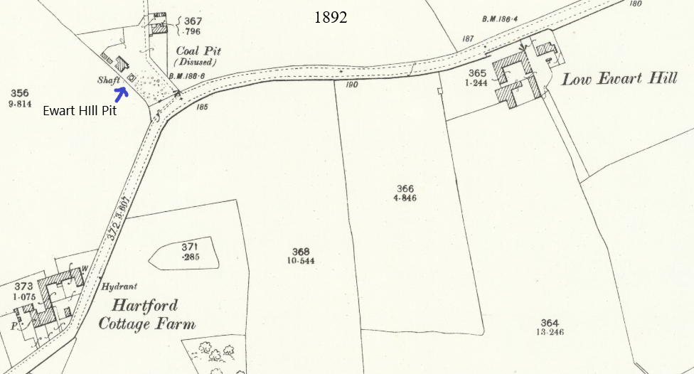
Thank you very much, James, another couple of bricks in my Bedlington wall. I’m matching history to the present and negotiating this website as well, interesting fun x
-
On 14/11/2013 at 01:06, HIGH PIT WILMA said:
Acorn Bank site was one of our favourite playgrounds when we were kids!
Sunday afternoon's,we used to play in the Euclids,when they were parked up on the top of the cut.
No security men in those days,weren't heard of..didn't need them.
We played in the driving seats,not locked,didn't damage anything,went down the cut and played on the feet of "Bucyrus Erie",which,at that time,in around 1954,[i was ten years old!]was the biggest walking dragline excavator in Europe.
At nights,after school at the old Whitley Memorial,we used to go over and lie at the edge of the cut,and look down a 200 foot drop,to watch Bucyrus chewing out the strata like toffee!
It looked magnificent,all floodlit up the jib,and around the cab.
It was an amazing sight to watch this huge beast,teeter forward on it's feet,the jib slowly bowing down slightly,then lifting it's whole weight,and slowly moving backwards,always backwards,about ten feet at a time.It's feet would then lift on a huge eccentric camshaft ,then they would move backwards and slowly thump down onto the ground,making the dust rise all around it.
What a sight
2,500 tons of steel walking as if it was on eggs!
Must rank as one of the finest amazing feats of engineering ever done in the world!
Yes,we watched the two Bailey bridges being built,over the Bedlington Bank road,and over the River Blyth.
We watched as Greenheart timber beams,more than two-feet -square,were sawn by hand,with two men at each end of a huge handsaw,must have been about six feet long.
These were to be used to build the trestle-work pillars to support the river bridge.
Greenheart is so dense ,it sinks in water!
I found this out,still as a kid,when we played down the river after the bridge was finished,and being used to transport coal to Bebside pit.
There were loads of bits of wood all lying around,on the river bed![i mean..BIG..bits!]
Loads of happy memories there,collecting fossils from the overburden heaps at the top of the picnic field......etc!
Getting rides in the Euclids,by canny drivers,who would let you push the lever to tip up the rear of the truck to empty it's load onto
a conveyor belt via a hopper....can you imagine it?.....this was before peoples brains were poisoned,and who,nowadays,would think that every canny bloke was a pervert out for young kids...these blokes just knew that THEY were kids a long time ago.......!
@HIGH PIT WILMA if you haven’t published yet it’s high time you did. Your beautiful description of the site and especially the movement of the machine is almost poetic, while reading it I could see it as if I was there. Who needs dvds when such graphic written records are available. I’ll be looking for more of your posts during my rummagings in Bedlington then and now, if that’s ok. x
-
2
-
-
16 minutes ago, Alan Edgar (Eggy1948) said:
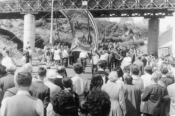
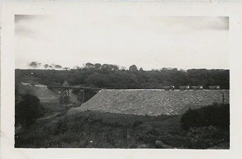
There was also a bridge, for the opencast traffic, across the road near the bottom of the Bedlington Bank that led the traffic to the one in the Woodhorn gallery photo. This is the only photo I can find of the one over the road :-
Thanks again, same forwarded to Josephine.
And houses on the right hand side of the picture. ALL the backs of those heads look like someone I used to know, that memory trickery again 😂!x the clothing and hairstyles all look 50’s but that doesn’t necessarily date it accurately, not everyone dresses bang up on date. Josephine has just texted-keen to explore for actual remains down the Bedlington bank- looks like that’s the next excuse to get the dogs out-after the rain stops. We’re very grateful for your continuing information feed, and I’m sure Poppy and Max appreciate you too xx
Currently trying to buy visitors pass for Woodhorn online - NOT a user friendly process! However, as it’s still raining then happy to rummage about online. -
11 minutes ago, Alan Edgar (Eggy1948) said:
No date given for the colour photo that was displayed at Wodhorn. If we could see the speakers on the bandstand we could work out what year
 .
.
All I can say is that it is 1952 or later as the first Northumberland Miners Picnic to be held at Bedlington was 1952. As it's colour I would assume it's mid 1960's.
Thank you very much Alan, I shared these pics with Josephine and she’s chuffed to see them, she’s sure she saw this bridge back in the day. We’re planning a trip to Woodhorn with the dogs to combine their run and swim with our visit to the museum- another very useful steer, thank you very much kind sir x
-
1
-
-
9 minutes ago, Alan Edgar (Eggy1948) said:
No idea if it's still on display at Woodhorn - haven't been to Woodhorn since the grand kids were small = 25 years ago🙂.
This is the only other photo of that bridge I can remember seeing - John Brown posted it on local Facebook group (I think)
Thanks again x Sorry to ask daft questions; regards R x
Concrete things in fields
in History Hollow
Posted
Evening @Canny lass, back from my travels, glorious day! I took pics along the way, most of which need editing so I’ll just share a couple now and the others when they’re tidied up. Didn’t find any remnants of Francis or Howard pits, there’s a lot of trees and quite dense undergrowth along the GLetch, or cultivated fields in the areas suggested by the map making it impossible for me to see anything notable. I took pics of the 2 bridges I crossed, both in deep gullies, the wooden one certainly en route for the Nland Ave path you marked on the map. Anyway, my bath is calling, speak soon Rx