Contributor Leaderboard
.thumb.jpg.7493ddab4a696108cf2b849323d3c155.jpg)


Popular Content
Showing content with the highest reputation since 24/07/09 in Image Comments
-
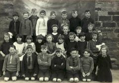
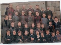 Coach Road is shown in blue on the attached 1897 map of Bedlington East End. The road is still there leading to Spring view and the last houses were demolished in the early 1950’s. The East End Church of England school was only about 250 yards from Coach Road so is fair to assume that this is the school in the photo. The school (shown in yellow on the map) was closed in the early 1900’s and the site is now part of Hollymount Square.3 points
 -
 Kings Coronation 20233 points
 -
 Taken today 13/6/2021:3 points
 -
 Humford baths. There were no trees at the A pit.3 points
 -
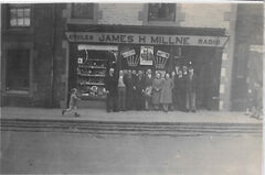
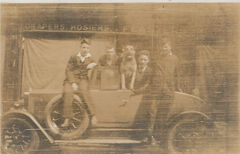 Definitely Bedlington east end, just a few doors along from Millne. Feasters were the first outlet for Westridge School uniforms. I'm afraid I can't confirm Bonzo's origins.3 points
 -
 My Gt Grandmother and Gt Grandfather had a building business. His name was James Johnson Mole and he married Catherine Easton. I often wondered if the cottages were any connection to her.. They lived in Gibson house in I think Rothesay Terrace. Their son Robert who was my Grandfather built a lot of houses in Stead Lane and you will still find manhole covers saying JJMole on the pavement in Bedlington. I was born at 9 Stead Lane, which my grandfather built and the house Pearmans next door as well and I remember very clearly the shop which I was sent to get messages for my Grandmother Alice Mole nee Green. In 1944 my Dad came home from the war and being a cockney we had to come doon sooth which broke my heart as I loved Bedlington. Alas, there is nobody I know now, either they moved away or died but my heart is still a Geordie and I can still speak the language fluently. We played with David and Arthur Fenwick, Olive Tipple, Tony Savilly who was called by us Tony is a billy because we could pronounce his surname, his Mum married an Italian and lived in the house right next to the shop. We played lots of games on Stead Lane, no traffic then, went to pledge doon the river Blyth, a children’s paradise The memories come flooding back. KATHLEEN NOTT - Maidstone Kent2 points
 -
Don't panic! Keep on clarting!2 points
-
Unfortunately CL I am at the stage where I don't want to start learning, and paying a monthly charge for, some new 'photshop' software . I enjoy the world moving forward and advancements in all fields progressing and making the working day easier for the professionals but I'm in my little world using the Microsoft Digital Image Pro 10 (MDI) software that I clarted with for many months finding out what I could achieve. When I first bought a new Desktop with Windows 7 I did export the MDI software from the vista PC and import it on the Windows 7 PC but the software wouldn't load so I have kept the old PC going for the last 5 years. I have, three weeks ago, replaced my Windows 11 Desktop PC (that one daughter said wasn't 'fit for purpose' ) for a new PC with i5 16GB processor and if I was into gaming I would have gone for the i7 with 32GB RAM but I am not into gaming, just clarting2 points
-
It's a man thing. Trust me, I'm a woman!2 points
-
Thanks for that little gem, @James! I thought that I'd researched my old school (Nedderton village) well but I never knew that it was once a church school.2 points
-
 I have just joined your page, after being directed here, by a kind soul on FB Ancestry page. My Father was baptised in the Netherton Church Mission, in 1919, according to his baptism certificate. I have just ordered his birth certificate, so hoping it contains an address. His Father was a miner at the time. The family name was Harrod. I am going to be in Blyth in June and am hoping to visit some of the places I have come across, whilst researching my ancestors. This page is great!2 points
 -
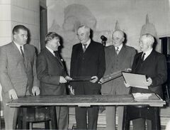
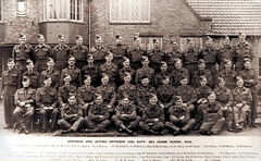 This gathering was more likely to have been for those officers based in the wider 'local area' attending a centralised training session at the Grammar School. Most of the villages/towns in the area of south Northumberland (and Nationwide) would have had Home Guard troupes under the command of an officer so I reckon they could be from Morpeth, Ashington, Blyth, and assorted villages.2 points
 -
 It has been converted into a house now.2 points
 -
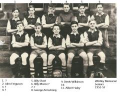 Number 6 is Bill Moore. My brother!2 points
 -
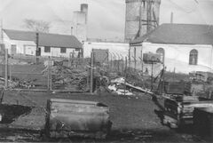
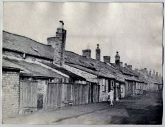 Thats Clifton Row in the picture .brings back memories of young harry saddler sitting on the fence between their house and ours telling me he was eating worms when it was spaghetti i lived in no26 i was only 4 or 5 at the time2 points
 -
 Wahey! Exactly as a remembered it! Costain Mining laid this temporary road and built the two bailey bridges, this one and the river crossing one, to take coal from the opencast mine at Acorn Bank, overland to Bebside Colliery, after public complaints about coal laden lorries speeding down Bedlington, otherwise quiet, main street, one of which knocked my faithful little dog down and killed him, having nearly hit me as we crossed the road. Tulip owned the fleet of old banger lorries, and they used ti belch out black smoke screens all the way up the road, after having climbed Bedlington Bank, empty, on the way back to the Opencast site, where the Golf Course is now, but this was around 1956. The 30-ton Euclids trucks, and also 42-ton Coal Haulers, used to make the bridges bounce e up and down as if they were made of elastic! Thanks for posting Alan! Made me happy ti see it again! Cheers Bill.2 points
 -
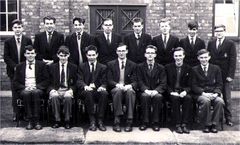
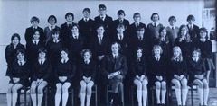 "Mr Todd!" He was deputy head of house (Hadrian)miss Ramshaw was head they were quite a good team I left in 1977 anyway a funny story about Mr Todd. I remember standing at the wall he came up to me I was wearing red & White Dr Martens, he looked me up & down & said are you a clown 🤡 boy basically he sent me home to change my shoes. Looking back on it now he was 100% right super photo that's made me smile with affection 👍🏻2 points
 -
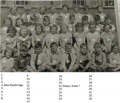
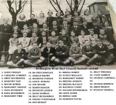 If this is 1948 then nr. 5 (Maud Bower) would be about 14 and that would be about right (born 1934). However, the closure of Netherton Colliery school couldn't have been the reason for the move to West End Council School. It was open long after 1948. I was a pupil there myself for a large part of the fifties.2 points
 -
George Campbell is No 33 on this photo. Recently, I sent George, who now lives in Scotland, a copy of this photo. Needless to say he was very happy to get a copy after all these years. George responded with some comments about the photo. George comments that most of the boys in the photo would be aged 13/14 years old and are still wearing short trousers. George provided following information: # 26 is Sylvia Golding (Maureen Curry was a year younger) # 34 is Herbert Nicholson The following pupils are missing from the photo for some reason: Mary Snaith (Netherton) Ella McLean Mary Wilton (may have gone to musical college) Peter Leithard (Netherton) The pupils which came from Netherton Colliery School when it closed are numbers 5, 12, 13, 14, 15, 18, 19, 34, 29, 30 in the photo.2 points
-
 Definitely bot Netherton. The only windows in Netherton were the four-paned sash type.2 points
 -
@Canny lass- some of Alan Dickson's paintings that he posts on the Bygone Bedlington, Cambois and Barrington groups. This photo I would say was 50+ years ago - could be Netherton Colliery - see text. Alan did join this group in 2014 but was only active for just under 5 months. Alan often posts a poem abut each of his paintings. This is a typical Alan Dickson poem :- Mind I had a funny dream , I was tossing and turning, Guess I had too much to dream, Just couldn't fall properly asleep, I remember I was aboot halfway counting the sheep. The cortins kinda fluttered and an old wummin came in from oot of the mist,came forward and sat on the side of the bed and gave me a kiss, I knaa I noticed the silver strands in her auburn hair, And the sparkly things dancing aboot in her eyes, Bugger this old lad was very surprised, To see his Mother putting a hand forward and stroking his head,, I reckon she must have thowt I was worried aboot this or that, But to tell the truth I didn't know what, She just spoke the once!! Son am nivvor very far away, I watch you every day!! I know your getting old, and the hairs whiter than grey, So your Mother thought she'd better call in and tell you, In her eyes, your still her little lad at the end of the day, She gave a little smile and drifted back oot in the mist, Now I wasn't sure if I had been dreaming or not. But I felt my hand ganning up to touch the spot where I thowt she had kissed, I must have fell back into deep sleep, Cos I couldn't see any more sheep.2 points
-
Here's one the right way up, but I still don't know who it is?2 points
-
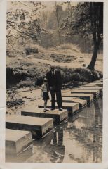
Andy's photos, and Jojo's,, definitely the stepping stones next to Humford Baths.2 points
-
Must be an early one @Andy Millne - that's the only one Iv'e seen where the chimney from the Water Works still exists when the place was converted to the swimming baths.2 points
-
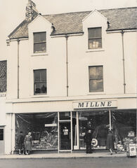
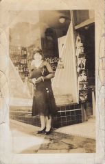 @Andy MillneDoes your family have any connections with USA? One of the magazines on the stand is The Delineator. This was an American woman’s “Journal of Fashion, Culture and Fine Arts” which was published in New York 1873 – 1930 before merging with Pictorial Review. This may help to date and place the photo. Also, we can read on the window: “ Victor, [FRENCH C]USTARD, [ICE] CREAM” (Text in square brackets is my suggestion). Victor French Custard Ice Cream was, according to Wiki, from a Californian company and anything to do with the company seems now to be very collectable (E-Bay). I don’t think this is Bedlington. Although 1930 is a bit before my time and things may have changed before I became familiar with the streets, I don’t remember ant pavements with diagonally laid paving stones. Neither do I remember anywhere with high bar stools – which I think I detect just inside the door. Could this be an American ‘ice-cream parlour’?2 points
 -
This may or may not be Bedlington but there is a suspicion that the dog may be the original "Bonzo"2 points
-
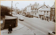
 Then & Now (Google Street View 2020)2 points
 -
.png.8ed7f3d4753c93e5f45344da507f8d26.png) The photo is taken from No 4 Old Colliery Row looking up towards the Black Bull. The gable end behind Mr Hemsted is No 6 Bell’s Place and this can also be seen in the google maps photo looking at the same view about 100 years later. The section of Bell’s Place that was demolished in the late 1940’s ran parallel and behind Old Colliery Row. To the right of the row were the toilets, and gardens. There was gas lighting and a couple of outside taps - no electricity.2 points
The photo is taken from No 4 Old Colliery Row looking up towards the Black Bull. The gable end behind Mr Hemsted is No 6 Bell’s Place and this can also be seen in the google maps photo looking at the same view about 100 years later. The section of Bell’s Place that was demolished in the late 1940’s ran parallel and behind Old Colliery Row. To the right of the row were the toilets, and gardens. There was gas lighting and a couple of outside taps - no electricity.2 points -
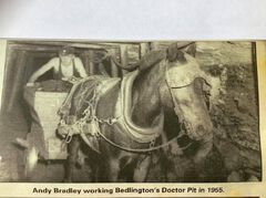 Andy is "Putting" or taking the tub outbye to a landing,where several full tubs would be coupled up,usually a set of six,where a "Driver" with a bigger horse would pull the set outbye from the landing to the shaft bottom,to be sent to Bank in the cages.Andy is going downhill when the pic was taken,as he has a wooden "Dreg" in the rear wheels to help slow the tub from over running the horse,even though the Limbers,["Limma's"] used to control the tub ,also the "Backstrap" on the Horse's Gears,around his rear end and fastened to his Bellyband...that pushed up against the Horse's rear flanks,and when he felt the pressure,he automatically pushed back against it and set his legs ..another great pic!2 points
 -
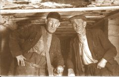 Note their pants!!.."Fustons"...indestructible thick warm material,most Miners wore Fustons,it was like ...what else wud ye wear doon a black hole?...not ya Wedding Suit! See the Steel corrugated Straps,[or "Planks"] holding the roof up? They were 6' long and canny heavy! Aboot three or four years ago,me and LBJ [me wee Lab x Dog],were waaking back from owa the Bomar fields ahent wor hoose,and a got me eye on summick familiar,sticking oot the thick bushes,next ti the Farmer's fence.A howked on and pulled it oot,it was one of these steel straps,bent at right angles,wi the weight of the roof underground,and it came from the Bomar pit heaps when they levelled it oot..noo hoo it ended up where it was owa the field a divvent knaa,but a fetched it yem on me shoulder,and mind,a was knackered when a got back yem!A hae it at the bottom of me garden as a feature,next ti me fence!! Just a little reminder of when a was strong enough ti lift them with one hand up ti the roof,and put a Lazy-Man prop in ti haad it there,so ye cud knock a prop in at each end to support the roof.[When a was in me Twenties - Forties...!] The Dr Pit was a "Naked Lamp Mine",under the M n Q Act 1954, so Willie Ward was ok using a Flashgun doon the pit,but wadn't hae been allowed doon any other "Flame Safety Regs " Pit.2 points
 -
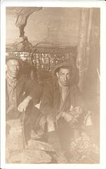 Aye,James,the metal canister held 5 lbs of Explosive Cartridges,what we ,[the miners] referred to as "Sticks o' Pooda"..[Powder]. That was the Legal limit that a miner was allowed to carry,under the "Mines and Quarries Act 1954"..of course,like any other Industry,rules were made to be broken! Down the Three-Quarter seam,at Bates,in the early 1970's,I used to be hurrying inbye to fire the Solid Drivage Maingate or Tailgate,or Back Drift,[1-in-4 gradient!],carrying a 50 lb Box of Polar Ajax,[33% Nitro-Glycerine..],under one arm,another 50lb Box on the other shoulder,and TWO - 10LB Packs ,one each side inside of my Overalls!! So I was carrying 120 lbs of High Explosives,with my Glennie on my belt,my Self-rescuer,also on my belt,my Caplamp and Battery,which weighed 9lbs...Heh heh...I was only in my Thirties,and strong as an Ox!! Noo,aam nearly 77 yrs aad,and a canna lift me aan shadow! Four feet of lovely clean coal here,maybe 4' -6" ,and great dry conditions,gud hard laminated Sandy Post Stone..with a wee bit of Blue on top of the Seam. A great pic of times gone by! Thanks for posting it! Bill.2 points
 -
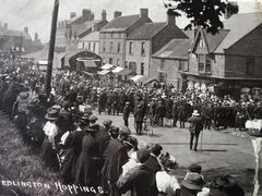 The following is an extract from the book “Leisure and Recreation in a Victorian Mining Community” by Alan Metcalfe ……….. …….”this, is illustrated vividly by the history of the Bedlington hoppings which were held for three days every Whitsuntide from sometime in the seventeenth century.72 The focal point of the three days of festivities was the Front Street and the adjacent side streets. The Hoppings attracted commercial attractions from outside Bedlington. The streets were filled with "numerous swing boats, galloping horses, shooting galleries, cocoa nut stalls, ice creamers, hokeypokeyites, Jaffa orange vendors, ginger bread stalls'.73 Over the years menageries, circuses, theatres, boxing booths and a variety of other entertainments visited the hoppings. However, changes began to appear in the 1860s and it was in the athletic events that changes were to be observed, In the I850s the programme consisted of a variety of footraces, three-legged races, old men's races, tilting the bucket and climbing the greasy pole for a leg of mutton, Over the next 5O years they became more "athletic' with the 120 yard handicap becoming the premier event. However, there were some things that did not change: the central role of the innkeepers and tradesmen in organizing and sponsoring the events. They were, from the outset, commercial enterprises. However what is most significant is that real lack of change in the location, Despite efforts from the police in the 1890s to remove racing from the Front Street and the various attempts to introduce alternative sports, the basic form of the hoppings remained unchanged, They provide a salutary lesson on the power of tradition in the mining communities” …………2 points
 -
The Old Colliery Row, better known as “The Aad Pit Raa” was built in 1840, 15 years before the Dr Pit was opened. According to Stephen Martin’s book it was built by a farming family, The Swann Brothers to rent to miners who were moving into Bedlington to work on collieries that were opening up in the vicinity. The Colliery Row was initially leased then sold in 1892 to the Bedlington Coal Company. The row was demolished along with Bell’s Place in 1950. Hollymount Square was built on this area immediately after the demolition of the rows.2 points
-
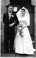
 Hi Ian. This was taken at The Old Vicarage next to St Cuthberts Church. I am the other person in the photo . Threegee is my father. If my memory is correct your grandparents lived at the top of Attlee bank but @threegee will know best.2 points
 -
2 points
-
I was Jammy............🥶2 points
-
'I think it was @Malcolm Robinson who took the photo without any clothing added' There are no leaves on the trees so he was probably quite cold standing there in the nude with his flasher in his hands!2 points
-
 When we were kids we spent hours in the spring catching toads from the 'A' pit pond(s). We didn't do anything with them, we caught them because we could. I remember there was competition to see who could catch the most. We put them back when we were hungry and went home for something to eat. We were never challenged by any blokes for being there. Every year my uncle wanted one in the spring for his greenhouse to catch the slugs that appeared overnight and the odd insect during the day. The toad he got that had fed well over the summer disappeared early winter. It didn't reappear the next spring. Did it get the urge to breed and dig its way out or escape through the open door, I wonder. We never caught any frogs in the pond and we didn't see any frogspawn, only the long strings of toad spawn. Frogs mustn't have liked the water taste or there wasn't any food there for them.2 points
 -
 Well that sorts that out! Lol2 points
 -
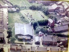
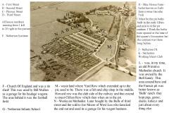
Hello Paul! Welcome to the forum. Look at the 1947 map which I posted above a couple of years ago. Howard Row was built in two blocks, with several years inbetween. The first block, the oldest of the Howard pit houses, is nearest the pit head and is where your father was born at nr.7 The numbers ran from 1-22 starting at the pit and going towards the social club. Your family may have lived there quite a while as there is a Lucas family at that address in 1911. I was born in 1947 at the other end of the street but have no memory of how it was because the family was möved to alternative accommodation shortly afterwards so that the houses could be demolished. I know, that at 3 yo I was still living the alternaive accommodation but the family must have returned to the newer colliery houses shortly after, because I started school at Netherton Infants at the age of 4½ in 1951. We lived then in Third Street. By then Howard Row and Yard Row no longer existed.They then seem to have been demolished a few years as the sites were overgrown with grass and bushes - a favourite playground area! The sites of the two blocks of Howard Row can be clearly seen in the ariel photo running north from the letter M up to the pit. Howard Row, nrs 1-22 were the smallest of the colliery houses with only two rooms. Yard Row consisted also of two rooms . The odd house had three rooms but this was because the residents built make-shift lean-toos over the outer areas However, the second block of Howard Row, nearest the social club was built with three rooms. Residents, even here increased some houses to four rooms using the same ingenuity as in Yard Row. As I said previously, I never saw these houses so yhe information I can offer is only what I've heard from older family members about living conditions in Howard Row.(my oldest siste was 20 years older than me). In his book on Netherton, Evan Martin shares this photo of Howard Row, presumably the gap between the two blooks. In the gallery you can find this photo which is reportedly of Clifton Row. I played with school friend in Clifton Row and can't remember it being as delapidated as this. Clifton Row was the newer, more modern of the pit rows before First-Third Street were built. I think this is Yard Row or even Howard Row. Both rows were built to the same plan I believe.2 points
-
@carly No 10 switched to No 9👍. I will let you know if we get any feed back from the Bygone Bedlington group.1 point
-
 Info updated.1 point
 -
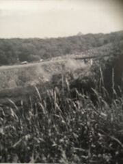
Picnic Day,in the mid-late 1950's,possibly very early 1960's,the Bailey Bridge over the road down Bedlington Bank was supported by two sets of pillars constructed from concrete drainage pipe sections filled with re-enforcing rods and solid concrete infills. The pillars were about three or four feet in diameter,and us kids watched the crews building these bridges [the river one also..on Greenheart wood Trestles..]. You can see Hunter's Farm house ,it's actually on the left side of the road,but perspective makes it look like it is on the right!..the field in the foreground,is Hunter's field,taken from the near top of Bedlington Bank. The Rostrum in the picnic field can just be seen over the built-up opencast road,and the white pillar under the bridge is what I have just described. The main road is out of sight ,and is to the right of the pic,and winds down to go under the Bailey bridge and over the river Blyth.1 point
-
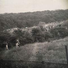 Hi Folks! Just caught up,been off due to health issues with both myself and my Wife! I reckon this pic dates back to the early-mid 1950's. The foreground field is where we used to walk through to get to a break in the hedge along the side of the picnic field,in the days long before it became Attlee Park,and before the concrete rostrum was built. The Council used to clear the cows out of the field,mow it,and build a temporary rostrum with scaffolding poles,and I think it was before steel poles came into use..they used wood poles lashed with ropes for the new Council House building programmes after the War,and I am sure they used the same method to put the speech platform up on picnic days. The Canopies are just visible in the left side in the mid-ground of the pic. The foreground field is now the tarmac'd car park at the bottom right of Bedlington Bank. Hunter's Farm and field was on the left side of the road,where the lovely house now stands ,opposite the field shown here. We kids were terrified of old Hunter,the Farmer,cos the older lads told us he had a Jelly gun,and would shoot you with it if he caught you in his field,and you couldn't get the jelly off your body!! Notice how lovely and thick the old free woods were before the thinning out programme started,in order to create the park and woodwalks. I spent me Childhood down this Field,and the woods,from Five years old!! We used to walk down the Bedlington Bank from Hollymount Square,no traffic,or very sparing traffic,at the least,mostly horse and cart traffic in those days...1949-- on!! Happy Days!!1 point
 -
Image posted by Dennis Reygate - Bygone Bedlingon group.1 point
-
 Formerly The Turk's Head public house now abandoned.1 point
 -
 Copy of the comment posted by @Jammy (at the end of the photos)1 point
 -
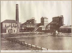
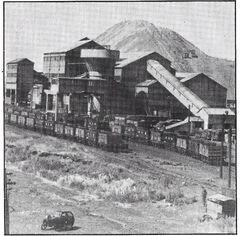 HPW Before the plant in the photo was built there was an old plant on this site that washed output from the Aad pit. The “new” plant was built on the same site as the old plant and continued to use the same dump. The wash plant in the photo was about 10 year old when the photo was taken but the discard dump as you say had been in use for over 100 years. The difference with the new plant was that it washed coal from both the Doctor Pit and the “A” Pit. In James Tuck’s book he states that this was part of a modernisation plan at the time of nationalisation of the mines in 1947. I’ve attached another photo of the “new” plant looking from the other side of the plant.1 point
 -
 About 1965, and shows where the damaged cables from the machines underground were stored prior to being loaded onto reels to be sent to Ashington Workshops. The job took place first thing every morning and was normally carried out by apprentices in all weathers. When job was finished it was off to the canteen! In the background, the John Shaft, airlock, lamp cabin and winder.1 point
 -
 When My Wife and Me got wor first hoose,in 1970,at West Terrace,in Stakeford,our next door neighbour was Ed Fearon's Parents.A lovely old couple! He is instantly recogniseable in this pic..never changed!1 point